Development of a trajectory planning tool for a highly automated aircraft
- Thesis by: Börge Kessner
- Supervisor: Prof. Gudrun Klinker, Ph.D.
- Advisors: Andreas Dippon, Volker Schneider, Lars Peter
- Time: Mar - Jul 2016
Abstract
Although automation has become an important aspect in aviation today, a faultless implementation and accurate prediction of automation behavior is still a challenge for engineers. Thus, a cooperation of several TUM institutes and an aircraft manufacturer is currently researching these fields with the aid of a highly automated research plane that is capable of proceeding a given trajectory defined by waypoints automatically. Because the detailed planning and correct prediction of such a flight path was almost impossible with the existing setup, the objective of this interdisciplinary thesis was to develop a concept and a first prototype for a trajectory planning tool, where a flight path could be generated and visualized in a two- and three-dimensional environment. The applied research resulted in the fact that with open source graphics libraries like OpenSceneGraph good rendering back ends already exist, although no projects have broached the issues of visual trajectory planning and prediction in such great detail so far. After a theoretical studying and conception phase, in a practical part a prototype software could be developed, capable of rendering different maps and terrains as well as fully defined flight paths. A great focus was thereby set on modularity and expandability to allow further developments of the software.Motivation
Like in almost every part of our life, the trend toward automated systems and processes is also growing rapidly in the field of aviation. Aircrafts are equipped with more and more complex autopilot systems reducing the workload of the cockpit crew. As a result, larger and larger aircrafts become operable by a single pilot. As a downside, exceptional conditions can lead to situations the computers cannot handle any more and hand over the full charge to the crew resulting in very stressful and dangerous situations for the pilot and his aircraft. To avoid this deficiency higher degrees of automation or even autonomous flying features are desirable to enable an aircraft autopilot to deal with every imaginable setting and to guide an aircraft safely through every environment. Nevertheless, the correct and precise prediction of a trajectory flown by an aircraft controlled only by an autopilot is still a challenge. To face these new tasks a collaboration of the TUM Institute of Flight System Dynamics, the Chair for Computer Aided Medical Procedures and Augmented Reality and the Austrian aircraft manufacturer Diamond Aircraft is currently doing a lot of research in these fields.Setup of the project
The Institute of Flight System Dynamics is owner of a Diamond DA42 aircraft that was modified to enable the onboard autopilot to navigate automatically to a given position in space and by daisy-chaining such waypoints even proceed a whole flight path without any pilot interaction. During such an experimental flight there is always a safety pilot on board as well as a test engineer who can check all relevant flight parameters. Additionally, the aircraft is connected to a ground control station via a wireless data link, where additional parameter and aircraft behavior observing is possible as well as the upload of flight paths to process.The trajectory planning tool
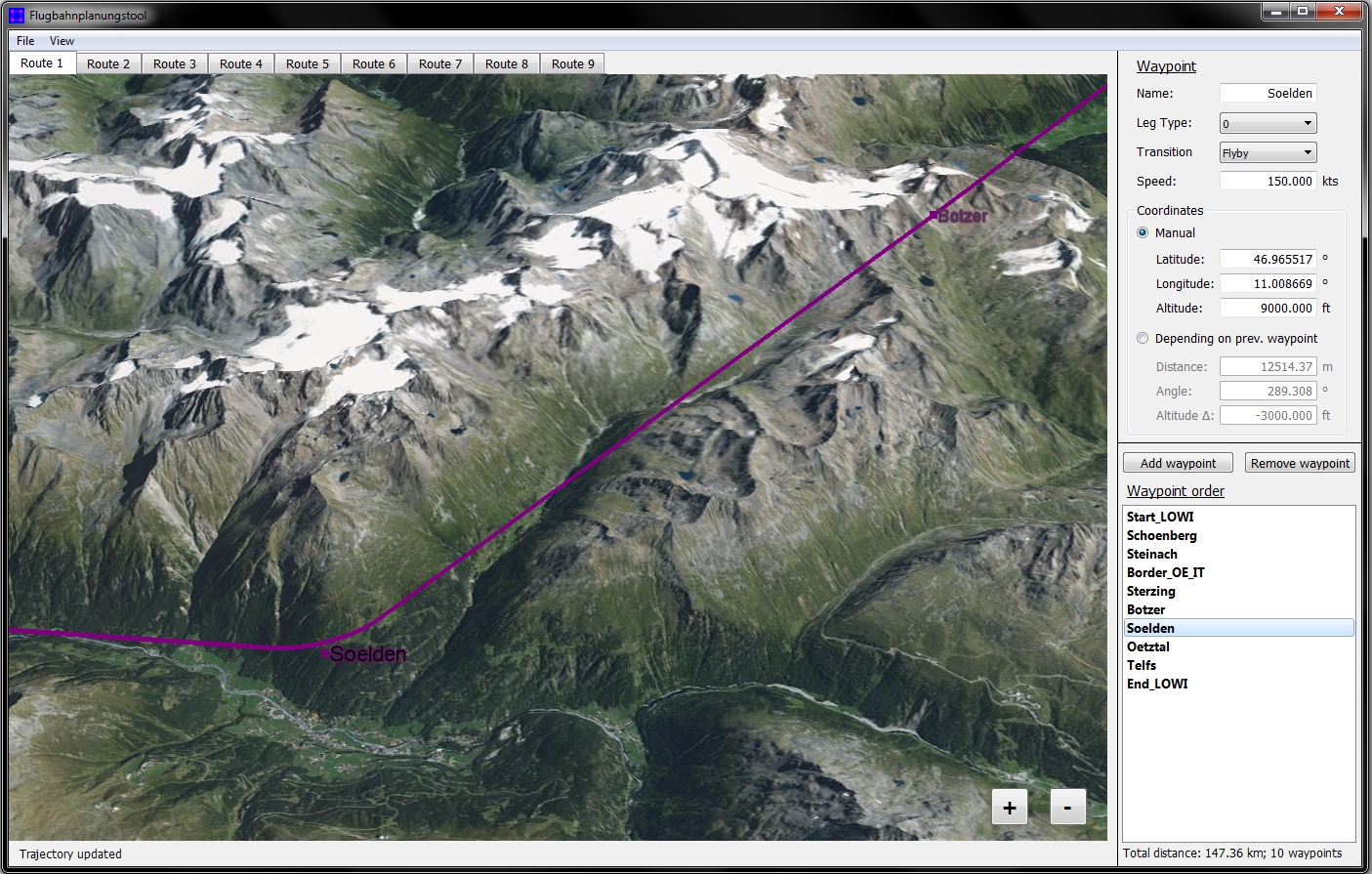
The goal of the thesis was the development of a concept and a first prototype for a software application for creating and managing trajectories for the Institute’s DA42 aircraft. It should offer easy and intuitive user interaction for defining new waypoints and connecting these waypoints to form a flight path together as well as the possibility to load, save and export trajectory data. The most important component of the tool should be a map or terrain view, where the waypoints and trajectory geometry could be displayed to the user. To ensure platform independence, a C++ environment was chosen with Qt as windowing system and the OpenGL -based OpenSceneGraph and osgEarth libraries as rendering backend for the map and terrain background. Because osgEarth offers easy loading of different sources for geographical content like tile map services or web map services from configuration files, this functionality could be integrated easily guaranteeing a wide exchangeability of map or terrain data. osgEarth also comes with the option for rendering geometric primitives like points and straight lines, that could be used for creating the trajectory’s appearance. As another advantage, osgEarth includes some cache functionality for storing downloaded map or terrain data and allow offline work. There exist different interaction methods for creating or deleting waypoints in the tool, including intuitive double-clicks on the map/terrain or the use of corresponding buttons in the window layout. To allow the user the modification of parameters of a waypoint, a waypoint editing panel exists showing all values of the currently selected one, including a name, aircraft passing speed, position, ARINC424 leg type and transition type. The trajectory is updated automatically with a value change. When adding a new waypoint to the flight path the user can choose two types for assigning a position, either by defining an independent latitude, longitude and altitude or by defining a distance, course angle and altitude difference from the previous waypoint of the trajectory. The second technique allows the creation of geometric flight paths with e.g. an exact rectangular shape or the moving of a whole flight path to a different map area if every waypoint of a trajectory except the first one depends on its predecessor. A great focus is set on the precise rendering of the trajectory line. It basically consists of straight lines between the waypoints with transition curves in between. The user can choose between fly-over and fly-by maneuvers. To grant an adequate in- and output functionality, the trajectory planning tool comes with different loading, saving and export functions. Flight paths can either be saved and loaded in an own file format or exported as vector data, that can be read and processed by the Institute’s DA42, or as KML file, allowing the user to view the waypoints in other applications like Google Earth, too. In a separate settings window all application options can be set, including cache policies or the definition of the resource files for the two-dimensional map and the three-dimensional terrain view.Outlook
Because the thesis just produced a prototype software application so far, a lot of possibilities for extensions exists. There is for example the plan to exchange the transition representation consisting of straight lines and fixed-radius curves with a detailed simulation of the real DA42 aircraft behavior to get the most accurate flight path prediction possible. However, also for every other random aircraft a more detailed approach for calculating the trajectory curvature is desirable, as well as the general integration of more aircraft-dependent parameters like service ceiling or maximum speed. Another important aspect is the checking for faulty trajectories, for example if a trajectory lines goes straight through a mountain or two waypoints are too close to each other to allow the performance of a specified flight maneuver or transition. These situations, that have to be checked by a visual inspection of the planned flight path so far, need to be displayed to the user with a highly noticeable warning. Other ideas for further developments include the possibility for a direct upload of a trajectory to the Institute’s DA42 or more user dependent settings like font and color style.Gallery
|
(By Estormiz (Own work) [CC0], via Wikimedia Commons) |
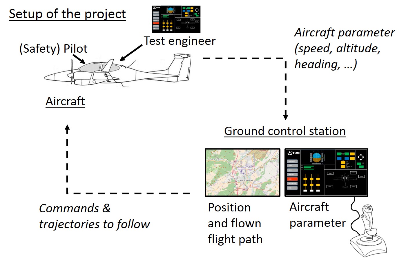 Setup of the project
|
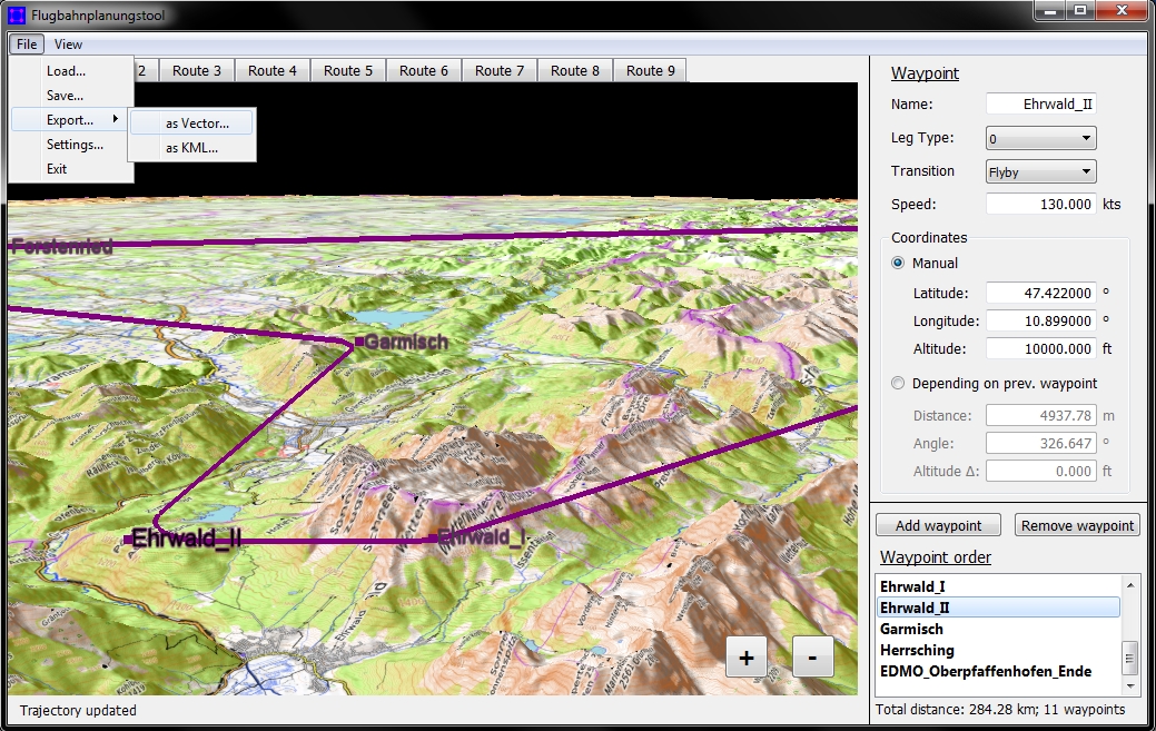 The trajectory planning tool in action
|
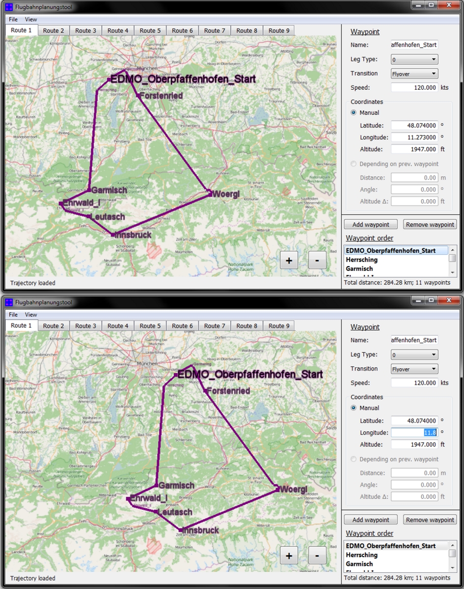 Moving a whole trajectory
|
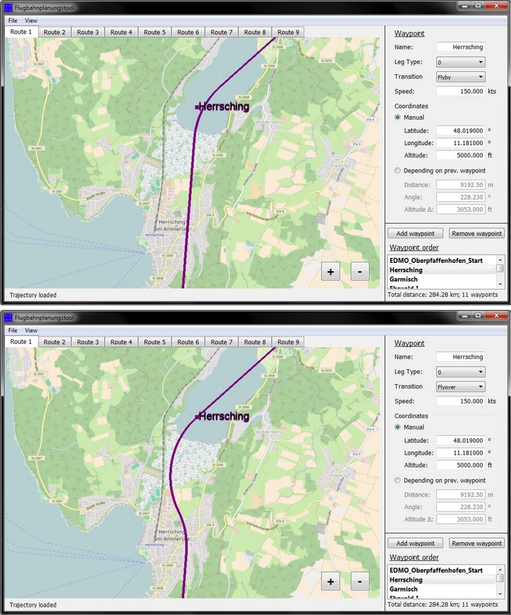 Fly-by and fly-over transition
 |
 Alpen-Rundflug
 |